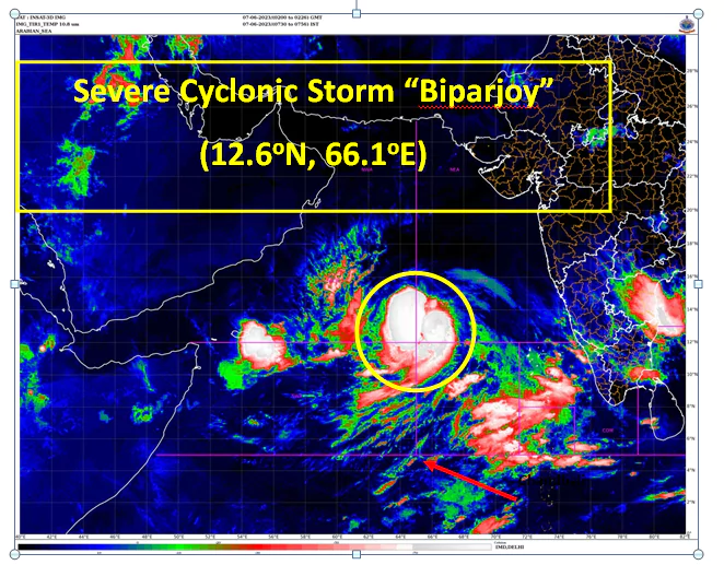
The Indian Meteorological Department (IMD) has issued a warning as Cyclone ‘Biparjoy’ strengthens and transforms into a severe cyclonic storm over the east-central and adjoining southeast Arabian Sea. The latest bulletin states that the cyclone is expected to intensify further and become a very severe cyclonic storm within the next twenty-four hours.
With the approaching cyclone, harsh weather conditions and rough seas are expected, accompanied by strong winds reaching speeds of 135-145 kmph, gusting to 160 kmph, over the next three to four days. In light of this, the IMD has advised fishermen not to venture into the sea.
As of 2:30 am, Cyclone ‘Biparjoy’ remained stationary over the east-central and adjoining southeast Arabian Sea. At present, Cyclone ‘Biparjoy’ is located approximately 900 km to the west-southwest of Goa, 1020 km towards the southwest of Mumbai, 1090 km in the south-southwest direction of Porbandar, and about 1380 km to the south of Karachi.
Cyclone Biparjoy Effect: High-Speed Winds Expected in Karnataka, Maharashtra, and Kerala
In anticipation of the approaching cyclone, the IMD has issued a wind warning for the next five days, specifically for the southwestern states.
7th June: Gale winds are expected to sweep through the east-central Arabian Sea and the neighboring regions of west-central and southeast Arabian Sea, reaching speeds of 80-90 kmph, with gusts reaching up to 100 kmph. These winds may strengthen further to 95-105 kmph, gusting to 115 kmph, in the evening of 7th June. Strong winds and rough sea conditions are also expected in the adjoining areas of the west-central and south Arabian Sea, as well as along and off the north Kerala-Karnataka-Goa coasts.
8th June: Wind speeds are expected to increase to 115-125 kmph, gusting to 140 kmph, in the evening. Areas along the Karnataka, Goa-Maharashtra coasts should be prepared for strong winds.
9th June: Wind speeds may reach 135-145 kmph, gusting to 160 kmph, in the evening. Harsh weather and rough sea conditions are expected in the adjoining areas of the South Arabian Sea, as well as along the Karnataka, Goa-Maharashtra coasts.
10th June: Strong gale-force winds, ranging from 145 to 155 kilometers per hour, and occasionally gusting up to 170 kilometers per hour, are anticipated over the central Arabian Sea. The cyclone’s impact will also be felt in the nearby regions of the beautiful south Arabian Sea and along the picturesque coasts of Karnataka, Goa, and Maharashtra.
Fishermen Warning
Considering the safety of fishermen, the IMD has issued a warning advising them not to venture into the sea until June 10. Fishermen currently at sea are urged to return to the coast immediately. Here are the specific directions issued by the IMD:
- For the safety of our courageous fishermen, it is advised to avoid venturing into the central and nearby regions of the south Arabian Sea between the 7th and 9th of June.
- Fishermen should avoid the central and adjoining areas of the north and south Arabian Sea on 10th June.
- Along with the Kerala-Karnataka coasts, fishermen are advised to stay away from the Lakshadweep-Maldives areas on the 6th and 7th June. Similarly, fishermen should avoid the Konkan-Goa-Maharashtra coasts during 8th to 10th June.
The IMD continues to monitor the system closely, and the next update will be issued at 8:30 am IST on the 7th of June, 2023.

