Trending Today
- BMC Initiates Removal of Uneven Mastic on Coastal Road Near Haji Ali Following Viral Backlash
- Panvel Exit on Mumbai-Pune Expressway to Be Blocked for Six Months for Construction!
- New Arm of Mumbai Coastal Road Opens, Cutting Travel Time from Haji Ali to Marine Drive; Final Worli Section Expected by March
- Mumbai-Pune ‘Missing Link’ Project expected to completed by August 2025
- BMC to Roll Out Smart Parking App—Know the Details here
Mumbai is going through one of the most significant infrastructure development projects, Mumbai Metro. It is a crucial and ambitious project for Mumbai, owned and supervised by MMRDA. With new metro lines, many areas of Mumbai will be more interconnected with each other sooner.
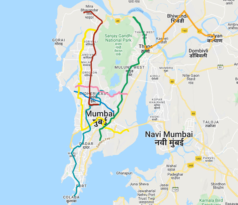
In the below Mumbai metro route map, we have covered and tagged all Mumbai metro train routes and stations. Each Mumbai metro route shows the correct station name and proper location on the map.
Currently, Mumbai Metro Line 1 (Blue Line), Mumbai Metro Line 7, Mumbai Metro Line 2A and Navi Mumbai Metro are fully operational. 12 more lines are currently under construction.
If you find any issue or need any correction to the map, please let us know.
Below we have covered all Mumbai metro route maps, which are currently operational and planned.
Mumbai Metro Lines Details
| Metro Line | Name of Corridor | Colour | Stations | Length (KM) | Status |
|---|---|---|---|---|---|
| Mumbai Metro Line 1 | Versova – Andheri – Ghatkopar | Blue Line | 12 | 11.4 | Fully Operational |
| Mumbai Metro Line 2A | Dahisar(E) – Andheri West | Yellow Line | 17 | 18.6 | Fully Operational |
| Mumbai Metro Line 2B | Andheri West – Mandala | Yellow Line | 22 | 23.6 | Under Construction |
| Mumbai Metro Line 3 | Colaba – Bandra – SEEPZ | Aqua Line | 27 | 33.5 | Under Construction |
| Mumbai Metro Line 4 | Wadala – Mulund – Thane – Kasarvadavali | Green Line | 32 | 32.32 | Under Construction |
| Mumbai Metro Line 4A | Kasarwadavali – Gaimukh | Green Line | 2 | 2.88 | Under Construction |
| Mumbai Metro Line 5 | Thane – Bhiwandi – Kalyan | Orange Line | 17 | 24.9 | Under Construction |
| Mumbai Metro Line 6 | Swami Samarth Nagar – KanjurMarg – Vikhroli | Pink Line | 13 | 14.7 | Under Construction |
| Mumbai Metro Line 7 | Dahisar (East) – Gundavali | Red Line | 13 | 16.5 | Fully Operational |
| Mumbai Metro Line 7A | Andheri (E) – CSI Airport | Red Line | 2 | 3.17 | Under Construction |
| Line-8 | CSIA – NMIA | Gold Line | 7 | 35 | Proposed |
| Mumbai Metro Line 9 | Dahisar (E) – Mira Bhayander | Red Line | 8 | 11.38 | Under Construction |
| Line-10 | Gaimukh – Shivaji Chowk (Mira Road) | Green Line | 9 | 9.2 | Approved |
| Line-11 | Wadala – Chhattrapati Shivaji Maharaj Terminus | Green Line | 11 | 12.7 | Approved |
| Line-12 | Kalyan – Dombivali – Taloja | Orange Line | 17 | 20.7 | Approved |
| Line-13 | Shivaji Chowk (Mira Bhayander) – Virar | Purple Line | 20 | 23 | Proposed |
| Line-14 | Kanjurmarg – Badlapur | Magenta Line | 40 | 45 | Proposed |
Mumbai Metro Map 2024- All Lines
Below Mumbai metro route map covers all Mumbai metro lines with detail of stations located on the map.
If you think, it’s helpful, then please help to share with others.
Map will be updated soon.
Map will be updated soon.
Map will be updated soon.
Navi Mumbai Metro Map 2024
The below map cover only Line 1 (Phase-1) for Navi Mumbai Metro Map. Other phases will be updated soon

