Postal Index Number (PIN), also known as PIN code, is a six-digit unique numeric code of post office numbering used by India Post. In order to deliver mail quickly and efficiently, the postal code (PIN Code) was introduced in India on 15th August 1972 by Shriram Bhikaji.
The PIN Code system was first introduced on 15th August 1972 by Shriram Bhikaji, who had served as an Additional Secretary in the Union ministry of communications.
The objective behind implementing the Postal code system was to simplify the sorting of mail and increase mail delivery efficiency. It was also important that the mail be delivered to the right person. Before Implementing the PIN Code system, mail was hand-sorted and relied majorly on the local knowledge of its intended destination.
However, it got more complicated when duplications of names of various places appeared across the country, which created more confusion. Also, multiple languages and misspelled street and place names made it difficult to deliver mail to the correct destination.
PIN code is a six-digit number, and each digit has a particular meaning. Below is an example of Mumbai Pin Code of Bhayander area.
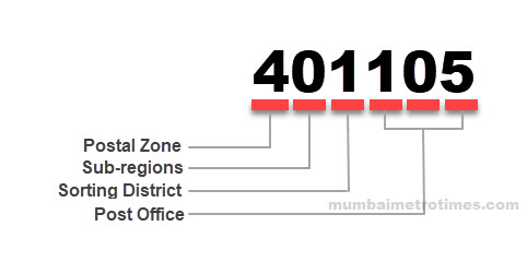
First Digit: Postal Zone
The first digit indicates the postal zone region in India, which ranges from 1 to 9. There are nine postal zones, including eight regional zones and one functional zone for the Indian Army. The digit 9 is reserved for the Indian Army Postal Service.
Second Digit: Sub-regions/ states or Union territories
The second digit in the PIN code represents the sub-region that can be either States or Union territories.
Third Digit: Sorting District
Combined with the first two digits, the third digit represents the headquarter of the largest city in the region, which is also called a sorting district or sorting office.
Fourth Digit: Service Routes
The fourth digit represents the route on which the delivery post office is located within the sorting district. The digit is 0 for the delivery post office located in the core area of the sorting district.
Last two digits: Delivery Office
The last two digits represent the delivery post office within the sorting district, starting in chronological order from 01. Delivery Post office starting from 01 indicates the General Post Office (GPO) or head office (HO) in the area.
There is no difference between PIN code, ZIP code, or Postal Code, and they all represent the same thing. Each country uses its own term to describe its postal code. Pin Code/Postal Code/Zip Code basically helps to identify the area in your city and its purpose is same. For example, the Postal Code term is used in Canada, the ZIP Code term is used in the United States and the Philippines, the Postcode term is used in the Netherlands, etc.